


iNavX
Marine Navigation

Description de iNavX: Marine Navigation
La navigation maritime est simplifiée avec iNavX - le traceur de cartes portable n° 1 au monde. Accédez aux cartes marines, aux cartes, à la météo, à l'AIS et plus encore !
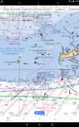
iNavX est la seule application à vous offrir une couverture cartographique mondiale complète, à partir de tous vos fournisseurs de cartes préférés, y compris la TOUTE NOUVELLE iNavX Professional+ Global Chart ! Entièrement activé avec un accès direct, iNavX permet aux utilisateurs d'accéder au plus vaste ensemble de cartes marines et de cartes de plusieurs fournisseurs, notamment :
• Cartes iNavX Professionnel+
• Latitude bleue
• Explorateur
• La météo de Ther
• Guide des voies navigables
• … et plus
Comment iNavX fait passer la navigation marine portable au niveau supérieur ?
• Marins - Planifiez des itinéraires de navigation avec la gestion des waypoints et des itinéraires. Bénéficiez d'une gestion proactive de la voile avec les prévisions météorologiques GRIB, puis surveillez avec les superpositions AIS et l'intégration avec vos systèmes embarqués. De plus, vous pouvez vous souvenir de vos meilleurs emplacements de navigation en géolocalisant des photos.
• Plaisanciers - Restez à jour sur les conditions de navigation avec des prévisions qui incluent les courants, les vents et la houle. Gérez votre équipement de navigation avec l'intégration d'instruments nautiques, puis enregistrez de superbes itinéraires de navigation à partager avec le journal de suivi.
• Pêcheurs - Découvrez de nouveaux lieux de pêche en recherchant des trous et des criques. Localisez les meilleures conditions de pêche en identifiant les fronts froids et enregistrez vos meilleurs spots de pêche avec des marqueurs illimités.
Fonctionnalités avancées - iNavX est l'application la plus riche en fonctionnalités disponible pour tous les besoins de navigation et de navigation à un prix avantageux :
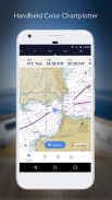
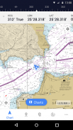
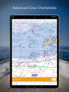
Traceur de carte avancé
• Tracez votre position en temps réel à l'aide du GPS intégré de votre appareil
• Panoramique, zoom et rotation des cartes (y compris le parcours vers le haut)
• Imprimez des graphiques détaillés à utiliser en combinaison avec l'application
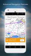
Navigation avancée
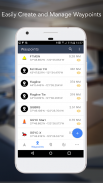
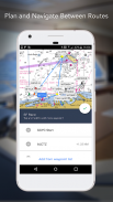
• Créez des waypoints et planifiez des itinéraires pour naviguer entre eux
• Le journal de suivi vous permet d'enregistrer votre itinéraire
• Importer/exporter des données au format KML (Google Earth) ou GPX
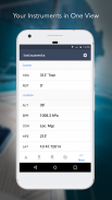
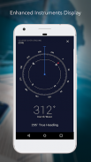
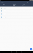
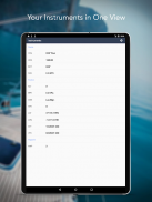
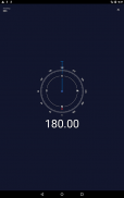
Instrumentation avancée
• Prend en charge les données NMEA sur TCP/IP (en utilisant le Wifi)
• S'intègre aux GPS externes, aux récepteurs AIS et aux transpondeurs
• Connecter les instruments nautiques : Profondeur, Vitesse, Vent, Moteur, Batteries, etc.
Boîte à outils essentielle
• Prévisions météo GRIB
• Marées/courants
• Alarme de mouillage
• Intégration AIS
• Recherche de port/d'aide à la navigation
Téléchargez iNavX AUJOURD'HUI et recevez automatiquement une copie gratuite des cartes matricielles marines NOAA RNC États-Unis haute résolution officielles et à jour.
COMMENTAIRES
"iNavX est l'original et toujours l'une des meilleures applications de navigation."
– Marin pratique
"L'application de navigation la plus complète et considérée par beaucoup comme la norme"
– Magazine Voile
"L'application de cartographie marine n°1 recommandée"
- iMarineApps
iNavX est compatible avec : C-MAP, Theyr Weather, Waterway Guide, AIS, Brookhouse, DigitalYacht, ShipModul, vYacht, Vesper Marine, NMEA 2000, Chetco et plus encore.
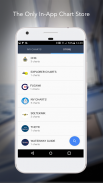
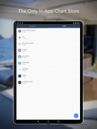
NOUVEAU MAGASIN DE CARTES
Achetez tous vos graphiques préférés. Les abonnements aux cartes varient selon la carte et le fournisseur de 9,99 $ à 199,99 $ par an, facturés sur votre compte iTunes, qui se renouvellera automatiquement à moins d'être annulé au moins 24 heures avant la fin de la période en cours. Le renouvellement automatique peut être désactivé à tout moment en accédant aux paramètres de votre compte dans iTunes après l'achat. Aucune annulation de l'abonnement en cours n'est autorisée pendant la période d'abonnement actif.
REMARQUE : L'utilisation continue du GPS en arrière-plan peut réduire considérablement la durée de vie de la batterie.
PLUS D'INFORMATIONS
Site Web : http://inavx.com/
Guide de l'utilisateur : http://inavx.com/help/
Conditions d'utilisation : http://inavx.com/terms
Politique de confidentialité : http://inavx.com/privacy
iNavX: Marine Navigation - Version 1.6.6
(03-08-2024)
iNavX: Marine Navigation - Information APK
Version APK: 1.6.6Package: com.gpsnavx.iNavXAncienne Version de iNavX: Marine Navigation
Autres versions


Applications de même catégorie

Vous pourriez également aimer...


